 FAO Map Catalog
African Water Resource Database
Type of resources
Available actions
Topics
Keywords
Contact for the resource
Provided by
Years
Representation types
Update frequencies
status
Scale
-

Full value-added derivative of ASCII GEOnet January 2006 gazetteer baseline, including non-diacritical names. ASCII is American Standard Code for Information Interchange. The GNS_GZTR shapefile data layer is comprised of 1083354 derivative point gazetteer features derived based on 1:250 000 data originally from GEOnet. The layer provides nominal analytical/mapping at 1:250 000. Data processing is complete globally, this is an African subset. Acronyms and Abbreviations: ASCII - American Standard Code for Information Interchange; GNS/GeoNet - NIMA?s Geographic Names Server Gazetteer of Named Locations.
-
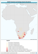
Threatened to endangered species watershed boundaries based SAIAB and HYDRO1k. Source: SAIAB and HYDRO1k, "river" flow, and watershed networks based on the GTopo30. The AQSP_THRTND_PY shapefile data layer is comprised of 92 derivative polygon aquatic species features derived based on 1:2 000 000 data originally from SAIAB. The layer provides nominal analytical/mapping at 1:2 000 000. Acronyms and Abbreviations: SAIAB - South African Institute for Aquatic Biodiversity; HYDRO1k - Global Hydrological 1 kilometre database of hydrologically filled DEMs; DEM - Digital Elevation Model; GT30/GTopo30 - Global Topographic 30 arc second DEM database, nominal 1km postings.
-
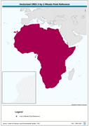
Vectorized CRES 3-by-3 Minute Point Reference. The CRES_PT shapefile data layer is comprised of 1004351 derivative calculated water temperature features derived based on 0.5 degrees resolution data originally from CRES/FAO. The layer provides nominal analytical/mapping at 1:220 000 000. Acronyms and Abbreviations: CRES - Centre for Resource and Environmental Studies, The Australian National University (ANU).
-
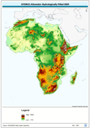
An hydrologically filled version of the GTopo30 DEM employing a Afro-centric Lambert Azimuthal Equal Area Projection. The H1K_LAEA grid data layer is comprised of 9194x8736 derivative raster hydrologically filled dem features derived based on 1 kilometer data originally from HYDRO1k. Acronyms and Abbreviations: GT30/GTopo30 - Global Topographic 30 arc second DEM database, nominal 1km postings; DEM - Digital Elevation Model.
-
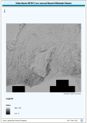
Volta Basin SRTM 3 as Based Hillshade Mosaic. SRTM is Shuttle Radar Topography Mission. The HSHD_MOS grid data layer is comprised of 13201x14401 derivative raster hillshade features derived based on 0.000833_ data originally from SRTM 3as v.2.
-
Derivative of the above "Null" SRTM 3-arc second dataset with terrestrial void areas backfilled with SRTM-GTopo30 DEM, 3204 Arc-Grid tiles. Source: FAO
-

Compilation of FAO Soil great group and major attribute characteristics with country boundaries removed. The SOILS_PY shapefile data layer is comprised of 4909 derivative vector soils features derived based on 1:5 000 000 data originally from FAO. Acronyms and Abbreviations: FAO - Food and Agriculture Organization in the United Nations.
-
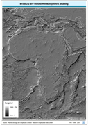
ETOPO2 2 arc-minute Hill-Bathymetric Shading. ETOPO2 is a 2 minute Elevation Topographic DEM including bathymetry. The ETOPO2_HSHD grid data layer is comprised of 5400x10800 derivative raster hillshade | bathymetry features derived based on 0.03333_ data originally from ETOPO2. The layer provides nominal analytical/mapping at 1:12 500 000. Acronyms and Abbreviations: ETOPO2 - A 2 minute Elevation Topographic DEM including bathymetry; DEM - Digital Elevation Model.
-
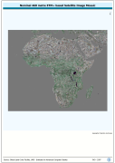
ETM+ based natural-color image mosaic base contrast-lightened for better visual integration with 1:1m scale cartographic vector data. The AF_ETM_BASE image data layer is comprised of 18910x23158 derivative image satellite based imagery features derived based on 465 metre data originally from ETM+ Browse.
-
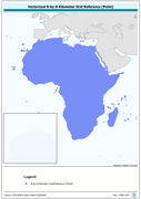
Vectorized 8-by-8 Kilometer Grid Reference (Point). The RFE_PT shapefile data layer is comprised of 471688 derivative calculated precipitation features derived based on 8 kilometers data originally from EDC. The layer provides nominal analytical/mapping at 1:35 000 000. Acronyms and Abbreviations: EDC - USGS EROS (Earth Resources Observation Systems) Data Center.